Jane’s Walk 2018
A Tale of Three Cities
Table of contents
Introduction
History of Notre-Dame-de-Grâce
Early History of the Town of Hampstead
The Beginnings of MacDonald Avenue
Building Apartments on Queen Mary Road
The Arrival of Michael Hornstein
An Evolving Style
Bibliography
Introduction
Anyone looking at a map of the City of Côte Saint-Luc (CSL) immediately notices two anomalies. CSL has two exclaves: two areas, each consisting of only a few blocks of territory that touch no other part of the municipality. They are around ten blocks away from the main part of CSL and from each other. How did such a strange geographical situation come to be?
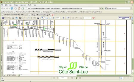
Figure 1: A close-up showing the relationship between the main part of the municipality of Cote Saint-Luc and the exclave of its territory on MacDonald Avenue.
History of Notre Dame de Grace
The answer to this mystery didn’t begin in the territory of present-day CSL. Notre-Dame-de-Grâce was a vaguely defined region called Côteau Saint-Pierre that stretched from what would become Atwater Avenue to Lachine. It originally included the territory of the City of Westmount, the Borough of CDN/NDG, the City of Côte Saint-Luc, Hampstead, Montreal West and more.
The first Europeans settled the area eight years after the founding of the colony of Ville-Marie, on November 18, 1650. Jean Descarries (or Descaris) dit le Houx and Jean Leduc, from Igé, Perche, France both received thirty acres of land [i] and built their homes on what is currently the McGill University Health Centre (MUHC). Members of the Hurtubise family also lived in the area and were given land grants shortly after the founding of Ville-Marie in 1642. The goal of this activity was to make a settlement to protect Old Montreal from surprise attacks by Native Americans. Visiting the hospital today, one notices that it sits on a cliff overlooking downtown. It was a perfect lookout to protect against surprise attacks for the inhabitants of the early settlement. Houses built by these settlers still remain today on Upper Lachine Road.
The Monument Historique de la Maison Hurtubise, 563 Chemin de la Côte-Saint-Antoine, Westmount, QC H3Y 2K5 is a bit younger and was built by the Hurturbise descendants. You can read more about these families in the article on the History of Côte Saint-Luc.
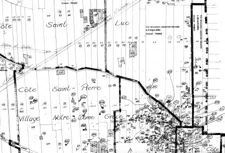
Figure 2: A map showing the early divisions of farmland along Cote Saint-Luc Road
Early History of the Town of Hampstead
The early history of the Town of Hampstead is inextricably linked to the financial activities of Sir Herbert Holt. Born in Ireland and trained as an engineer, he was in charge of building the Canadian Pacific Railroad through the Rocky Mountains.
After that project was finished in 1886, Holt managed a number of financial endeavors in Montreal. By 1914, he had amassed a substantial fortune through shrewd business dealings. He was the owner and/or director of over 300 companies and was president of the Royal Bank of Canada. He directed the Montreal Light, Heat and Power, which later became Hydro-Québec. He also had a hand in Montreal’s tramway system as well as the building of the Ritz Carlton Hotel. Holt was reputed to have had a net worth of $200 million — although some have estimated his wealth at more than 10 times that amount.
Holt and a group of seven other entrepreneurs were able to prevail upon the Quebec government to incorporate the Town of Hampstead on Feb. 19, 1914, when the area was primarily forest and farmland. Holt and his clique of wealthy and highly organized companions had honed their skills developing real estate in the Circle Road area of what is now the Borough of NDG.
The limits of the new city were created from farms on Lots 69, 72, 73, 74, 76, 77, 80 and 81, which were all in the Municipality of Côte Saint-Luc. In an article in the Montreal Daily Mail dated March 7, 1914 the difficulties related to the creation of the new town are noted. Among these are the fact that two of the original farms in Côte Saint-Luc lay between the eastern limits of the new town and the City of Montreal. The article mentioned that this land would become part of the City of Montreal, which never happened.
The Beginnings of MacDonald Avenue
The first families in the area of MacDonald Avenue were descendants of those families that had been given land grants around what is now the MUHC. They divided the unsettled land using the rang system. Communication and transportation were facilitated by creating narrow long plots of land which extended roughly north and south from Côte Saint-Luc Road. That dirt trail was a line of communication in from the river and from rue Saint Jacques.
Once the farms of the settlers were registered as lots, the land which is now MacDonald Avenue in one of the CSL exclaves became part of Lot 68 and extended into Lot 65 which became Dufferin Avenue. As time passed and the frontier farming neighbourhood transformed itself into a majority English-speaking suburb of the City of Montreal, Alphonse Hurtubise, a descendant of the founding families of the district, sold his farm to a real estate speculator named Thomas Francis O’Brien. In 1873, shortly after that sale, O’Brien filed a plan to subdivide the farm into over 650 suburban building lots along two streets, one now being MacDonald Avenue and the other Dufferin Avenue in the Town of Hampstead. MacDonald Avenue at that time was called Monklands Avenue, but more will be told about how the name was changed later.
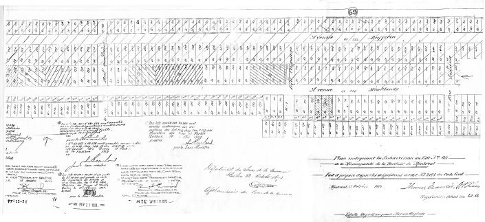
Figure 3: Part of the subdivision plan that created Dufferin Avenue and Monklands Avenue which became MacDonald Avenue
Although the subdivision of lots 65 and 68 became a legal fact in 1873, it was far from an urban neighbourhood for many years after that date. The 1908-1910 edition of Lovell’s Guide, a residential and business directory in Montreal for decades, lists only nine residents on Monklands Avenue, thirty-five years after the registration of the subdivision. Almost certainly, the streets were unpaved and water and sewer lines were not installed. The article in the Montreal Daily Mail discussed above mentions that the west side of MacDonald Avenue (whose name by then had been changed from Monklands) and both sides of Dufferin Avenue belonged to a land company, Sir Montagu Allan and the Montreal Jockey Club.
Notwithstanding who owned the land at that time, by November 3, 1924 at a meeting of Côte Saint-Luc Village Council, a letter from Mr. Owen Roberts to annex lands belonging to the Gault Estate either to Montreal or to Hampstead was discussed. Mr Roberts explained that he wanted to construct houses and required water, sewer, sidewalk and street facilities on Dufferin Avenue and Queen Mary. The council said that they could not meet his request for services and there would be no objection if his land would be annexed to either Hampstead or Montreal if they were willing to pay for these improvements. On November 24, 1925 Hampstead passed By-Law number 23 to annex 52.8 acres of the lands. MacDonald Avenue was not included in the arrangement.
Building Apartments on Queen Mary Road
Why did Hampstead’s By-Law number 23 not include the annexation of MacDonald Avenue? Probably the answer lies with Mr Sabbatino Damiani of Sabbatino Realties who had offices for years at 5548A Queen Mary in CSL but built and lived in a house at 16 Albion in Hampstead. In a telephone interview with his nephew Ron Martini of Ottawa on March 28, 2007, the nephew explained that his uncle built the apartment buildings on both the north and south sides of Queen Mary Road where it passed through what had been the original Lot 68. Ron said that when his grandfather began construction there was a gate across Queen Mary at the Union Cigar Star at Queen Mary and Décarie which he opened to get to his land.
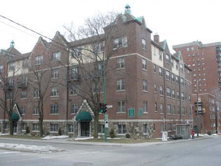
Figure 4: 5551-53 Queen Mary Road
The apartment building on the north side of the street is 5551-53 Queen Mary. In the interview Ron said both buildings were built around 1929, but the current owner’s administrator gave the date from documents as 1922. The building’s European construction methods include triple layer walls with double air spaces for insulation and a cement slab between street level and the second floor. This apartment building may have been the reason that Hampstead never claimed this area of CSL. Below is information about the history of the Town of Hampstead from their municipal website:
The founders of the Town of Hampstead envisioned a community where residents could be safeguarded from the chaotic mixture of residential, commercial and industrial zoning. The area- bordering on the City of Côte St. Luc, Notre-Dame-de-Grace, and the City of Montreal- was to be developed with houses of individual characteristics and high architectural standards. This original vision was laid out in a plan adopted by the provisional council of 1913-1914. The plan was based on a model for development that became popular towards the end of the 19th century. This model was known as the “Garden City” concept.
The Garden City is a conceptual framework that aims at establishing an idyllic suburb community. The plan offers residents some of the amenities of country living, by giving each family an individual home surrounded by ample green-space. Those interested in gardening, for example, could grow vegetables while still being able to devote some land to decorative gardening. This rural-oriented movement was a reaction to the overcrowded and unpleasant tenement areas, characteristic of the post-industrial city. Urban planners slowly moved toward more rural-based concepts, creating what came to be known as the Garden City trend.
The founders of the Town of Hampstead took the Garden City model one step further. Each house was assigned a generous-sized lot, with room for a maximum amount of trees, shrubs and green-space. Particular attention was also paid to the curving of the Town’s roads, as opposed to the usual grid-iron design, and to the strategic planning of its trees. The unique design adopted by the founders has had the effect of discouraging through traffic, while further distinguishing the appearance of the Town.[ii]
Unfortunately, the Garden City model that was incorporated into the original zoning of Hampstead did not allow for the construction of schools, fire houses or even town hall. Under the zoning of the time in Hampstead, if they had incorporated the territory of the apartment buildings, those buildings would have had to be torn down.
The Arrival of Michael Hornstein
Mr Michael Hornstein was interviewed by the author on September 5, 2006 at his office. He died on April 25, 2016 at the age of 95. He began building on MacDonald Avenue in 1954 and bought most of the properties on MacDonald Avenue that were in CSL. At that time, those properties contained mainly little houses. He kept the former owners as tenants, but there were no leases and the conditions were that they had to move when he needed the properties for construction.
Whether genius or simply good luck, Mr Hornstein realized the need for high intensity housing in the West End and the possibility of building it along MacDonald Avenue. Neither the Town of Hampstead nor the City of Montreal could impose zoning limitations on the area. When Hornstein started building on the street, Mr. Boyer of CSL had a few conditions, but they were really minor. The City of Côte Saint Luc did not mind what was done in the area.
Mr Hornstein’s first building on MacDonald was at 5020. Mr Hornstein built most of the north section of the digit. Besides the building at 5020, the properties that he built were 5500, 5360, 5350, 5320, 5304, 5160, 5150 and 5140. 5140 is the only condo which is called ‘Le Doray’. The Hornsteins lived there on the top floor in a condo unit with a large terrace (which is visible in Figure 8) and 15 foot high ceilings to accommodate their art collection. This last property was built in 1978. As a condo, he says the building sold very rapidly because the price at the time was $80 to $85. After the PQ election in 1976, Mr Hornstein diversified his company. Half of their operations moved to Chicago.
An Evolving Style
How did the buildings that Mr Hornstein built on MacDonald Avenue change between the first built at 5020 in 1954 and the most recent, the ‘Le Doray’ Condominium built in 1978.
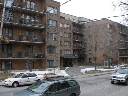
Figure 5: 5020 MacDonald which is south of Queen Mary Road (photo taken March 2007) which was the first building built by Hornstein on MacDonald Avenue in 1954
| Comparisons of two buildings | 5020 | 5040 |
| Date of Construction | 1954 | 1978 |
| Type of structure | Steel (to verify) | Steel (to verify) |
| Exterior Brick Dimensions | 7.25” L x 2.25”H x 3.75” D | 7.25” L x 3.75” H x 2.25”D |
| Exterior Brick Colour | yellow | red |
| Exterior Shape | Irregular but rectangular | Simple rectangle |
| Number of Floors | 6 | 17 |
| Balconies | Yes with metal balustrade | Yes with concrete balustrade |
| Entry Portico | Flat concrete | Concrete Honeycomb Slab |
| Window Construction | Double aluminum sliders | Double aluminum sliders |
| Parking | Underground garage | Underground garage |
| Swimming Pool | No | Yes |
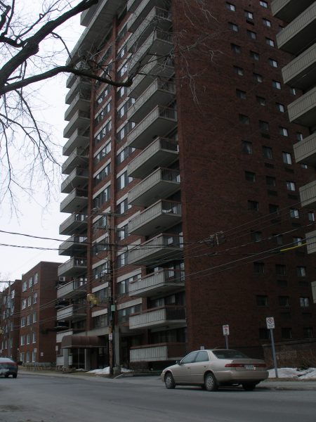
Figure 6: Built in 1978, 5040 MacDonald is the last building built by Hornstein on MacDonald Avenue. It is called ‘Le Doray’ and is the only Hornstein building on the street that was built as a condominium.
Comparing the first and last buildings built by Hornstein on MacDonald Avenue, one notices an evolving style as the team that built the buildings developed greater technical expertise and building technology itself evolved over the approximately 25 years of the period.
Perhaps the most noticeable development between the two buildings was their heights. Although the 5020 was six stories high, the standard Hornstein building almost always was double this, around seventeen stories. Only a guess, but this height probably represented the ideal between the ability to create space and the cost of constructing a skyscraper with all the costs involved in additional elevators and steel.
Also a noticeable change is the brick cladding. Starting with a standard yellow brick exterior in 1954, later buildings all used a standard brick, always in the same reddish tint, but laid on its side. The resulting gain in height represents an economy because the arrangement uses fewer bricks.
The shape of the two buildings also varied significantly. In the aerial shots below, look at the difference in the land around the two buildings which are on lots of identical street to back depth.
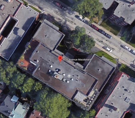
Figure 7: 5020 MacDonald from the air, June 2018
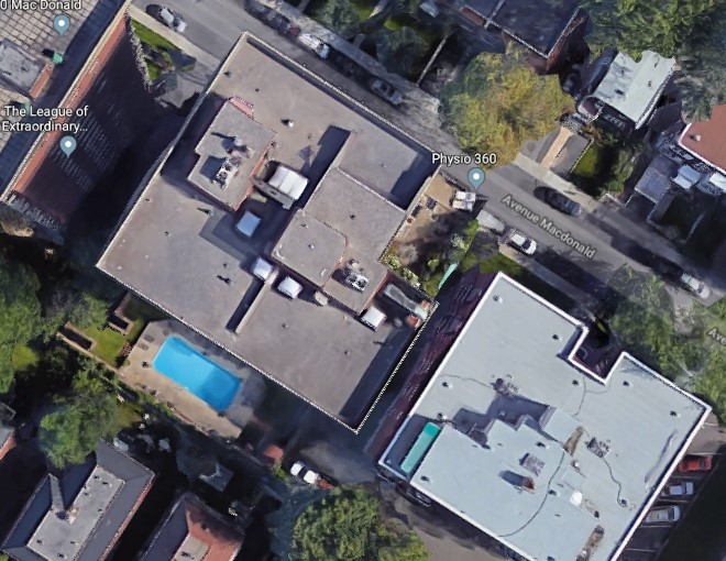
Figure 8: 5040 MacDonald from the air, June 2018
5020 has a drive on MacDonald. 5040 gained enough space in the rear to insert a swimming pool (which is partially over their parking garage) by eliminating the front drive and narrowing the plan of the building. The simplified form of the building also eliminates corners which can be problematic in terms of waterproofing and wasteful of materials during construction.
The City of Montreal approached Mr Hornstein during the Drapeau Era to see if he would be interested in being amalgamated into the city, but he wasn’t interested because the taxes would have been higher.
Bibliography
Les rues de Montréal
Éditeur Méridien par la Ville de Montréal
A History of Hampstead
Unpublished student paper by Danny Fry dated May 12, 1980 for professor W. Van Nus
Interview with Mr Hornstein – September 5, 2006 at his office
Telephone interview with Ron Martini – March 28, 2007
[i] From https://en.wikipedia.org/wiki/Notre-Dame-de-Grâce subarticle History consulted July 3, 2018
[ii] From https://www.hampstead.qc.ca/discover_hampstead/our_history/ consulted July 4, 2018
